Writing this, I kept thinking how the kid I was drove the back roads of Nova Scotia in the back seat, sandwiched between plump elderly women in stockings and floral dresses, my grandmother and any one of her sisters. As they pointed out possums, foxes, and The Measured Mile1 for me to view, whoever was driving would back up if I missed it. Driving there today, I look out at the scenery… and feel love.
In Chapters One thru Six, we met Sarah Rushton walking her land grant in 1827 Westchester, Nova Scotia with her daughter Elizabeth and grandchildren. Sarah, husband Jeremiah, and family were exiled from New York as Loyalists after the Revolution. Promised land by the British, the family boarded a ship, then walked for days, hauling their belongings. Fretting over her husband’s plan to move to Upper Canada, Elizabeth asked, “How will I have a baby by myself in the wilderness?” Sarah explained she’d avoided pregnancy as a refugee. The Rushtons labored to meet the terms of the land grant. Sarah regaled everyone with stories of soap- and candle-making and the hardships of making cloth. A chart detailed how women’s work was never done.
The Story of the Landowner’s Wife….a fictional look
“Mama.” Elizabeth sat down heavily after the children had run off. “You have so much land. Did you want to buy it all? Or did you want to have just the grant?” she frowned.
“I was happy with what we had, but your papa had a point. With six sons, we had to have land to leave them. And it made sense, while we had the money, to buy it when it came up for sale. He said, with more people coming all the time, more children being born, people would need that land, and we’d be there to sell it to them.”
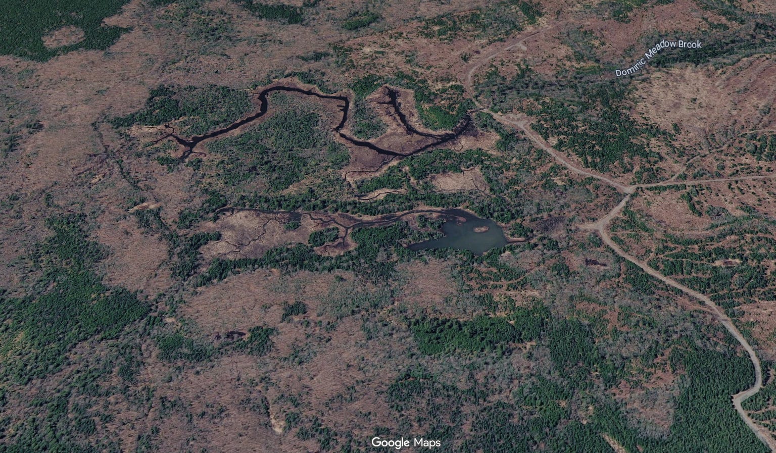
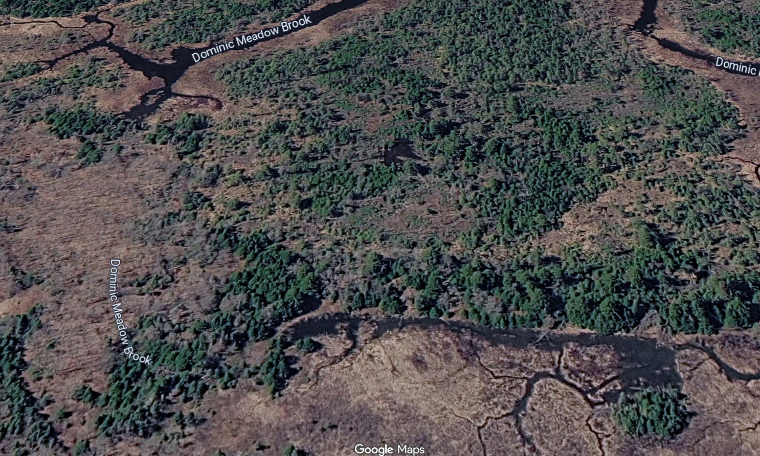
The following present-day Google images show the U-shaped brook, Dominic Meadow Brook, that Sarah and Elizabeth walked along in this story.
“But didn’t Papa lose some?” Elizabeth asked.
“Yes. He owed Lewis Purdy over sixty pounds, and we couldn’t pay it. It dragged on for three years. Such a scary time! Just when we thought everything was going well. We were afraid we might lose everything, so we sold some to your brothers. The sheriff auctioned off one of our lots and Lewis Purdy bought it for a song. Later, we bought the land back from your brothers. We even paid them extra for their trouble. We managed to save what we had sold to Jeremiah and Peter ahead of time, but we lost the piece Mr. Purdy won at auction for good.
“Your father needed my help, because he couldn’t sell it without me. I had to sign, that he wasn’t forcing me to sell off my dower rights. The justice of the peace, Henry Purdy, even took me aside and questioned me separately, to make sure I signed ‘without any threats or compulsion,’ as he put it. Next time it was Thomas Roach, the Justice of the Court of Common Pleas.”2
“Does every woman have dower rights?” Elizabeth questioned. “Do I?”
“Every wife,” Sarah replied. “It’s the law. Probably in Upper Canady too. Your husband can’t just sell away, or give away, what you have a right to. One-third of everything is yours.”
“I didn’t know that,” Elizabeth commented.
“You need to, going so far away, without your papa and me,” Sarah said. “You need to find out what your rights will be in Upper Canady before you go. A woman always has to have something tucked away in her pocket, just in case.”
Her daughter nodded soberly.
A Chronicle of a Landowner’s Wife…a factual account
Jeremiah and Sarah acquired and sold land in a complicated series of numerous transactions over the years, not all of which I have discovered in records. Their initial gain, of course, was the 500-acre land grant, Lot 5.
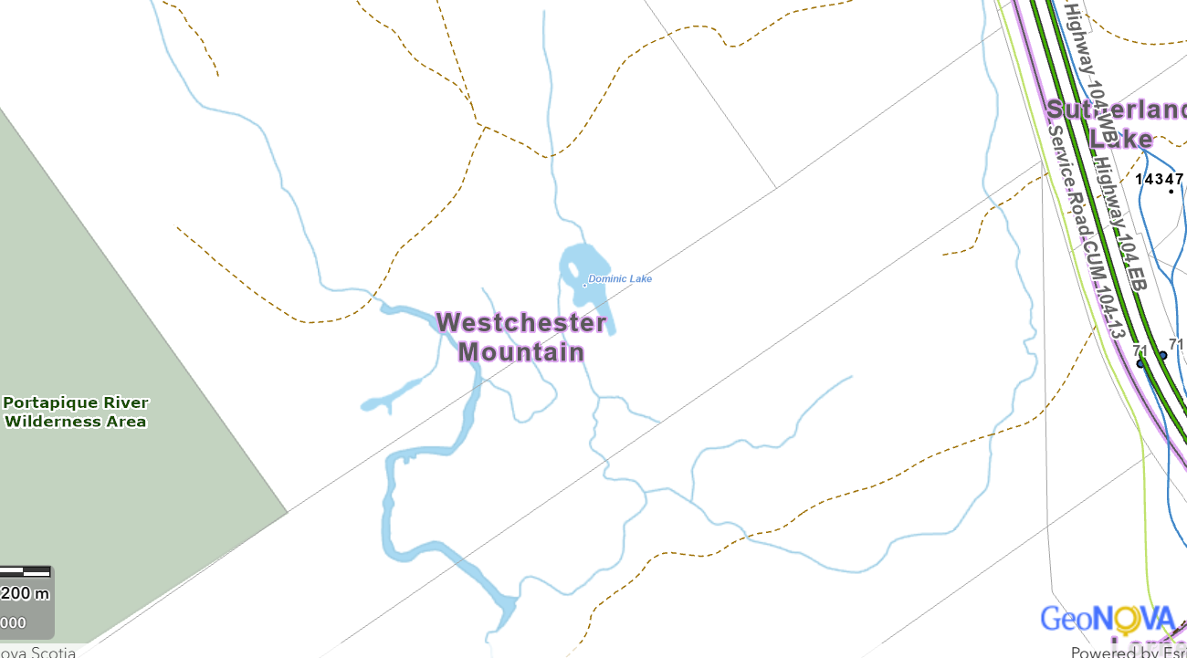
Sarah and Jeremiah’s land grant today: the rectangle from Service Road CUM 104-13 on upper right diagonally to lower left, including the U-shaped brook and the tain of Mountain3
The following timeline shows the transactions in chronological order:
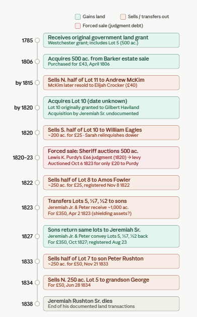
Sarah and Jeremiah made contracts concerning five different lots of land. To make it easier to follow, I have listed the transactions found in deed records by lot, geographically.
Lot 5: This was their most important property. As their original grant, given by the King in gratitude for loyal service, it appears to have held great meaning for Sarah and Jeremiah. They probably meant to hold it until their deaths and then have it pass to their descendants. It only left their hands twice, and even then only part and partially. Half was truly let go when, in Jeremiah and Sarah’s old age, their oldest grandson, George Rushton, son of firstborn Abraham, planned to marry. They broke up part of the grant to help him establish a homestead. On the 28th of June 1834, they sold him 250 acres on the north side of the Cobequid Road for the small sum of 50 pounds.
Another transaction, made eleven years earlier, seems intended to keep hold of the land. When Lot 5 was threatened by a judgment, as explained further below, they made sure they wouldn’t lose all of it by selling some to their sons.
Lot 7: Records don’t show when Jeremiah bought Lot 7, only when he sold it, in 1833 to his son Peter for £50. He sold 250 acres off the north side, lying on the south side of the road leading to Cumberland, joining Amos Fowler’s lot on the north. This deed was proved much later, February 24, 1845, and registered May 22, 1846, after Jeremiah’s death.
Lot 8: Possibly Sarah and Jeremiah’s very first purchase, this occurred when their neighbor Israel Barker4 of Lot 8 died intestate. Jeremiah bought 500 acres on the north side of Cobequid Road at public auction on the 11th of April 1806, for 43 pounds. On the same day, his brother Peter’s son William bought Israel Barker’s 250 acres south of the road for 13 pounds.
As this was the probate of a will, these purchases were not entered formally until the 28th of October 1811. William’s purchase was not mentioned. The document states that Jeremiah bought the whole 750 acres for the whole purchase price of 56 pounds. We don’t know why this happened; perhaps William changed his mind or was unable to come up with the money. A William Rushton got a land grant in River Philip; if he is the same person, which seems likely, getting land for free would be a good reason not to buy property.
In 1822, Sarah and Jeremiah sold part of Lot 8. “All that certain half right or share of land known by the number eight, laying and being on the Southwest side of the Post Road,” containing 250 acres more or less, went to Amos Fowler of Westmorland, New Brunswick, for £25.
The 500-acre portion of lot 8 went to Lewis Purdy in 1823 to satisfy the judgment mentioned below.
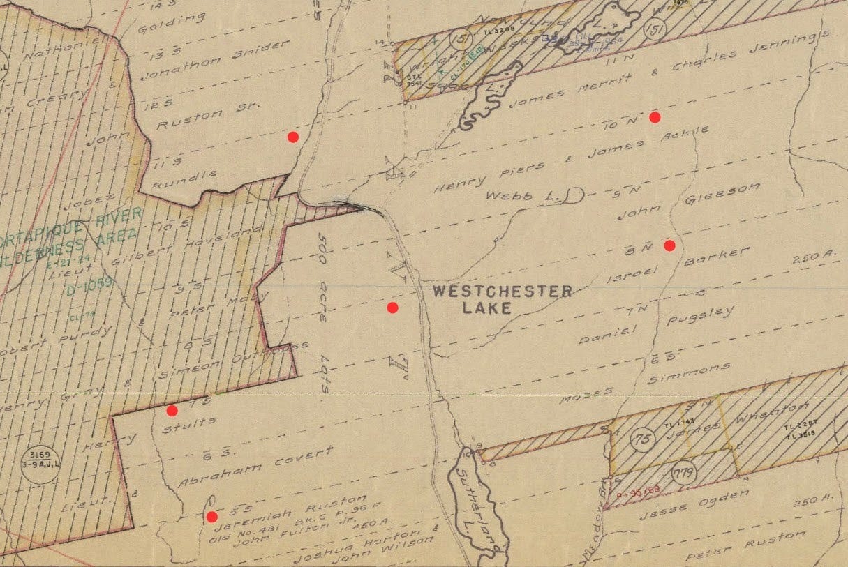
The Crown land grant map below shows the lands granted in Westchester. The Cobequid Road bisects the map north to south, roughly following the Portapique River. The red dots indicate lots in which Jeremiah and Sarah were involved as buyers, sellers, or grantees. If the red dot is by the grant number, 5S, 7S, 8N, etc., it indicates Sarah and Jeremiah bought the whole lot. If the red dot is by the road, it indicates they bought a section of the lot, I presume closest to the road.
Lot 10: How Jeremiah and Sarah obtained this land is unknown; Lot 10 was granted to Lieutenant Gilbert Haviland. But in 1820, Jeremiah and Sarah sold the south half, on the north side of the road leading from Londonderry to Cumberland, approximately 200 acres, to William Eagles for £25. Sarah was questioned separately from Jeremiah to be sure that she agreed to the sale without the coercion of her husband. This deed was registered September 26, 1822.
Lot 11: The only thing we know about Lot 11 is that before 1815, Jeremiah and Sarah must have bought all or part of it and then sold it to Andrew McKim. Andrew McKim conveyed it to Elijah Crocker.
The Judgment
Jeremiah suffered a significant setback in 1820. He had somehow become indebted to Lewis Kniffin Purdy for £66 15 shillings, a considerable sum of money. When Jeremiah didn’t pay, Purdy obtained a judgment against him in the Inferior Court of Common Pleas in the October term of 1820.
A standard common law writ directed the sheriff to seize the debtor’s property and raise the money owed. The sheriff could seize everything the person had to sell and pay the debt; the balance would be refunded to the debtor. The sheriff first looked for personal property: livestock, tools, household goods.
In Jeremiah’s case, the document states that no sufficient personal estate could be found, so his real estate was attached. The Sheriff of Cumberland County, Charles Henry Chandler, levied 500 acres of Jeremiah’s land in Westchester, described as lying between lands owned by Holmes and Jacob Rushton, formerly belonging to the estate of Israel Barker (Lot 8).
By common law, if the land was improved, which Jeremiah and Sarah’s was, it could not simply be sold. There first had to be an inquiry as to any possible rents or profits that could be gotten from the land. If they were insufficient to pay the debt within a certain period of time, then the court could order a sale. On the 2nd of April 1821, the sheriff caused the land to be appraised, and the appraisers declared that an annual rent of the 500 acres would not be sufficient to satisfy the judgment within two years.
After the two-year appraisal period expired, the sheriff was required to advertise the land for sale publicly. The deed states that the land was advertised in the Royal Gazette, the official provincial newspaper, once a week for three months, and also posted locally at Westchester. This public notice was a legal requirement to help the debtor by increasing the numbers of bidders at the auction to try to drive the price higher.
However, when the land was sold at public auction on the 6th of October 1823, Lewis K. Purdy was the highest bidder at £20. The sheriff then wrote out a deed to Lewis Purdy conveying all the interest and rights to the land from Jeremiah and free from the judgment. Twenty pounds was a very low price, half of the £43 Jeremiah had paid for 500 acres of the Barker estate back in 1806, and far less than the judgment debt of £66. Typically, in sheriff’s sales where the debtor was forced to sell, distressed properties often went for far less than they were worth.5
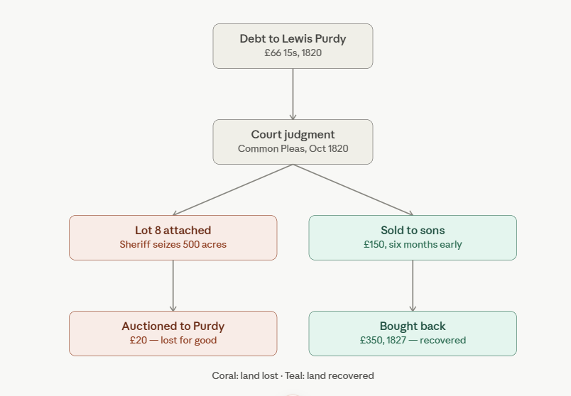
Uncertain as to what the result of the judgment would be, Sarah and Jeremiah sold portions of land. The 1822 sale to Amos Fowler may have been an attempt to raise cash, but the profit of 25 pounds was not enough to stop the auction. Their next tactic was to sell land to their youngest sons in order to at least keep it in the family.
Therefore, six months before the auction, Jeremiah Rushton Junior and Peter Rushton the Second bought Lot 5, the original land grant, described as 500 acres on the south side of the road, bounded by John Rushton the Second to the north and Joshua Horton to the south. In addition, they bought half of Lot 7 (250 acres on the south side of the road), and half of Lot 2 (250 acres on the north side.) For all these holdings, they paid their parents £150.
Once the danger was over, in October 1827, Jeremiah Jr. and Peter Rushton the Second sold these same lots back to Jeremiah Sr. for £350; more than double what they had paid four years earlier. The deed describes the same three parcels identically. Their neighbors and kinsmen, Isaac Rushton, Stephen Moore, and Nathaniel Webb6 supported the plan; they witnessed one or both deeds. It appears that Sarah and Jeremiah wanted to make sure their sons didn’t lose anything by helping them out of a jam; instead, they sweetened the deal by paying them extra as a thank-you.
Why did Jeremiah owe Lewis Purdy money? Why couldn’t he pay? What precipitated the crisis is unknown. However, 1819–1823 marked a severe economic depression following the end of the Napoleonic Wars. Credit contracted sharply and agricultural prices fell. Jeremiah and Sarah had already been selling land; perhaps they had been worried about money for some time.
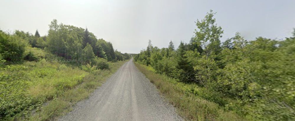
Along the Cobequid Road today, now running alongside Highway 104, Google Maps
Sarah’s Dower Rights
Altho Sarah had rights to land and property along with Jeremiah, her name never appears as owner or buyer. This is due to the law of coverture, which covered women under their fathers, husbands, or other male relatives for legal purposes. A woman could not independently buy or sell real estate, enter contracts, or take legal action in her own name. The concept of coverture began in medieval times, formally entering British common law in the 1700s. It ended in Nova Scotia with the passing of the Married Women’s Property Act in 1887.7
Wives’ rights had been expressed in British common law in the concept of dower. She was entitled to one-third of her husband’s property upon his death, until she died or became covered under a new husband. If a man sold a substantial piece of property, his widow could come back later and demand her dower rights from the purchaser. Therefore, purchasers were protected under the law by the wife explicitly renouncing her dower claims on that property.
This was effected by the wife swearing she agreed to the sale. Furthermore, courts assured themselves of her agreement by the privy examination, questioning her apart from her husband to ensure she was not being coerced. This is still practiced today.8 Sarah signed the privy examination with her mark in two documents: the sales of 1812 to Andrew McKim and 1820 to William Eagles.
In the 1812 sale, a justice of the peace recorded: “This day personally appeared Sarah Rushton wife of the within named Jeremiah Rushton and being by me examined aside from her said Husband acknowledged that she freely voluntarily and without any threats or compulsion from her said husband signed and sealed the within instrument.” The standard phrase “without threats or compulsion” is the legal formula confirming the examination was genuine.9
Privy examinations are important for genealogists: they are sometimes the only records showing that a woman existed, who she was married to, and where she lived or owned land.
Jeremiah and Sarah engaged in a complex back-and-forth of buying and selling over thirty years of property ownership in Westchester, Nova Scotia. By the time they died in 1838 and 1839, ever-growing warps and wefts of Rushton men and their wives owned land in an interwoven fabric close to each other.
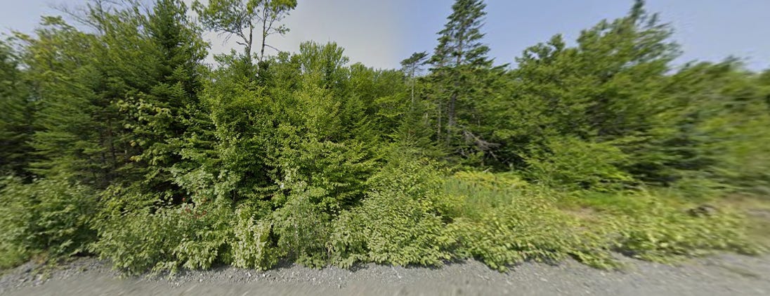
Sarah and Jeremiah’s Lot 5 land grant, seen from the road, present day10
All the above deed information is from Registry of Deeds, Cumberland County, Nova Scotia, familysearch.org thru their full search option.
I used Claude.ai to help me decipher, organize and analyze Jeremiah and Sarah’s many land transactions. I also used Claude.ai to make the timeline and flow chart and help me revise and edit.
Two signposts exactly a mile apart. Their purpose was for drivers to check the accuracy of their odometers.
Registry of Deeds, Cumberland County, Nova Scotia, Jeremiah Rushton, 1812, 1820, familysearch.org
https://nsgi.novascotia.ca/civic-address-finder
Israel Barker was most likely the father-in-law of Jeremiah’s sister Mary, who married Abraham Barker; Mary and Abraham named their son Israel. Cumberland County genealogies, Westchester Township Book, archives.novascotia.ca
https://nslegislature.ca/sites/default/files/legc/statutes/saleland.htm
Isaac Rushton was Sarah and Jeremiah’s second son; Stephen Moore was either their brother-in-law or son-in-law; Nathaniel Webb lived close by.
https://lawshun.com/article/how-was-the-doctrine-of-coverture-adopted-in-canadian-law
Dower rights still apply in Canada today when only one spouse owns a married couple’s home and wants to sell it. https://khlawgroup.com/when-does-the-dower-act-apply-in-real-estate-transaction/
Registry of Deeds, Cumberland County, Nova Scotia, FamilySearch.org
That this is their land grant is an educated guess on my part, based on the Crown land grant map showing a U-shaped brook, a current topographical map showing the U-shaped brook named Dominic Meadow Brook, and the same brook on Google Maps.
Comments
Post a Comment