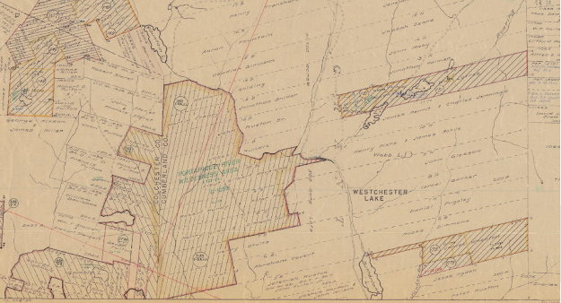
Here you can see the 500 acres of land granted to our ancestor Mary and John R. Rushton, Sr. in 1785. (not spelled quite right). They were our first Rushton ancestors in Nova Scotia. You can see their land goes right up to the Colchester / Cumberland county line on the west side, and has 2 streams running through it. Half their grant, on the west side of Fountain Lake Brook, later became the Portapique River Wilderness Area, government protected land. (see Rushton Pedigree chart)
The lines that mark the east end of their grant that look like = = = = = = is, I believe, a dirt road. The =========== line that follows the river is, I think, a paved road.
This is a current GPS map of the same land. The thick green line is the border of Portapique River Wilderness Area, same as above. You can see the same rivers and roads, which are now all paved. The railroad now crosses from northwest to southeast, and the thick orange line, NS Route 104 Trans Canada Highway, is also new.
But you can still see the borders of the land grant. The road to the east of Rt. 104 is still the eastern boundary. The line where the purple and green are in the same line is the western boundary, just like the county line above.
Now we can see the grant in the larger area of Westchester. Originally, the land Mary and John got was described as being "along the road to London-Derry." Later it was "on the Cobequid Road." In my opinion, that is now called Westchester Road if you want to drive there.
Towards the bottom of the map, just west of Sutherland Lake, you can see the land grant of Sarah and Jeremiah Rushton, son of Mary and John. Other relatives, William Coon, Peter Rushton, and possibly John Jr., have land grants here too.
Here is the whole map. You can still tell where Mary and John's land is by the Portapique River Wilderness Area on bottom left. The map shows part of Cumberland County, Nova Scotia, where it meets Colchester County, in the area of Westchester and Wentworth. The map is not one particular year; rather, it is a compilation of about 100 years of land grants, from about 1750 to 1850.
The cross hatched areas represent land that was returned to the government. Grantees had to meet the requirements or they lost their land: live on the land and within 10 years, have half the land under use, whether for farming, pasture, or timber.
"RUSHTON: Jeremiah, John Sr., and Peter RUSTIN (RUSHTON), Loyalists from Westchester, New York, each received 500 acres of land on the Cobequid Road, Cumb. Co., N.S. in 1785. (Loyalist and Land Settlement in Nova Scotia, p. 41)"
Virtually all the land in Nova Scotia belonged to the Crown. If anyone wanted any, they had to petition for a grant. Of course, once the land was granted to someone, they could always sell it to someone else. I have not yet researched what happened to this land later on.
Source:
"RUSHTON: Jeremiah, John Sr., and Peter RUSTIN (RUSHTON), Loyalists from Westchester, New York, each received 500 acres of land on the Cobequid Road, Cumb. Co., N.S. in 1785. (Loyalist and Land Settlement in Nova Scotia, p. 41)"


Comments
Post a Comment